It's 1944. The world is at war.
Somewhere in Europe, the beaches of Normandy are being painted red. In the Pacific, island by island. But here — in the Emirate of Transjordan, a small British-administered territory in the middle of the desert — a man named Charles Wilson is driving south from Amman with his camera and his wife Lorna.
His job isn’t to fight. It’s to feed the British Army. Wheat. Grain. Provisions. That’s what brings him to this corner of the world. But somewhere along the way, between the supply routes and the desert roads, he starts photographing everything he sees.
What he leaves behind is an archive that almost no one knows exists.
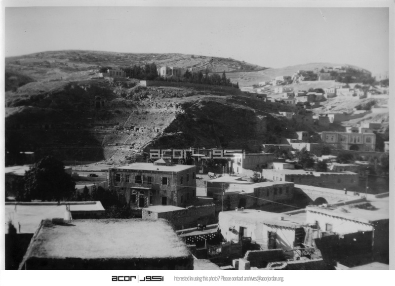
Amman — his base
In 1944, Amman is a small city still finding its feet. Wilson photographs the Roman Theatre — a structure built nearly two thousand years earlier when this city was called Philadelphia, one of the ten cities of the Roman Decapolis. A Greek inscription carved into one of its pillars ties its construction to Emperor Antoninus Pius, who reigned from 138 to 161 CE. It seats six thousand people. It still stands, perfectly intact, in the middle of what is now a capital city.
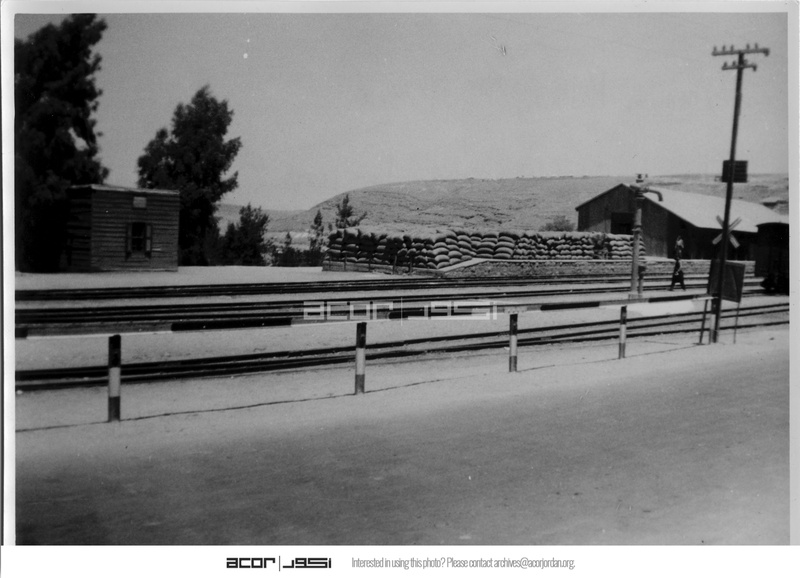
Across town, he photographs Amman Railway Station. The building is only forty years old at this point. The Hejaz Railway — ordered by Ottoman Sultan Abdulhamid II in 1900 and completed to its full length in 1908 — runs from Damascus all the way to Medina, with Amman connected to the line in 1904. Before the station arrived, Amman was little more than a village. The railway made it a city. By the time Wilson photographs it, Britain controls the line. It is hauling military cargo, not pilgrims.
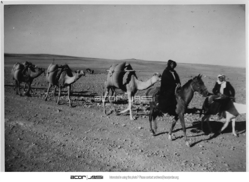
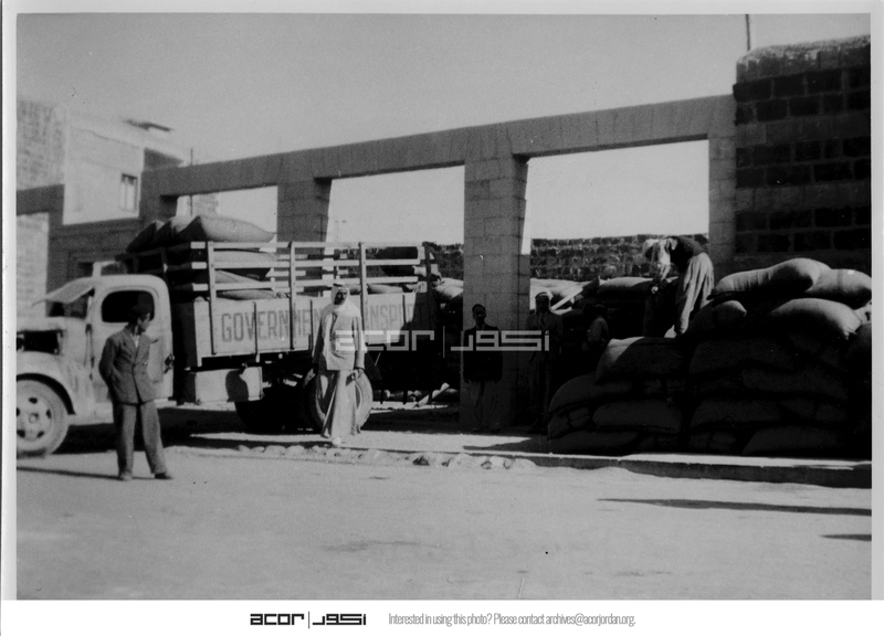
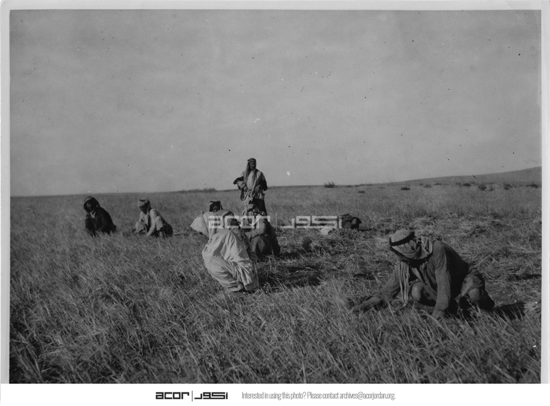
The wheat roads — Madaba
This is actually why Wilson is here.
Outside Madaba — the ancient city famous among scholars for something Wilson probably walked right past: a sixth-century Byzantine mosaic map of the Holy Land, hidden under the floor of St George’s Church since its rediscovery in 1896, still the oldest surviving cartographic depiction of Jerusalem ever found — Wilson is photographing something far more immediate.
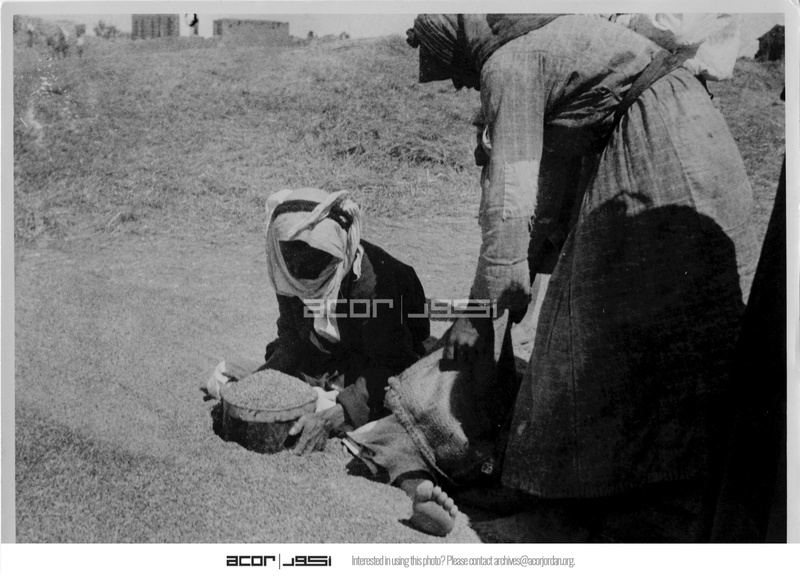
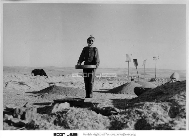
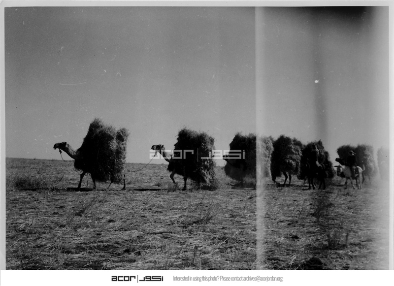
Threshing floors. Camel caravans loaded with sacks of grain. Circassian carts stacked high with wheat. Men measuring and weighing before the loads are sent north. He photographs it all. The logistics of war, documented in the dust of an ancient plateau.
Down in the Jordan Valley at Jisr Sheikh Hussein, he photographs the buying station — the place where grain purchased from local farmers is collected and prepared for distribution to British forces. It is unglamorous work. It is what’s keeping the army alive.
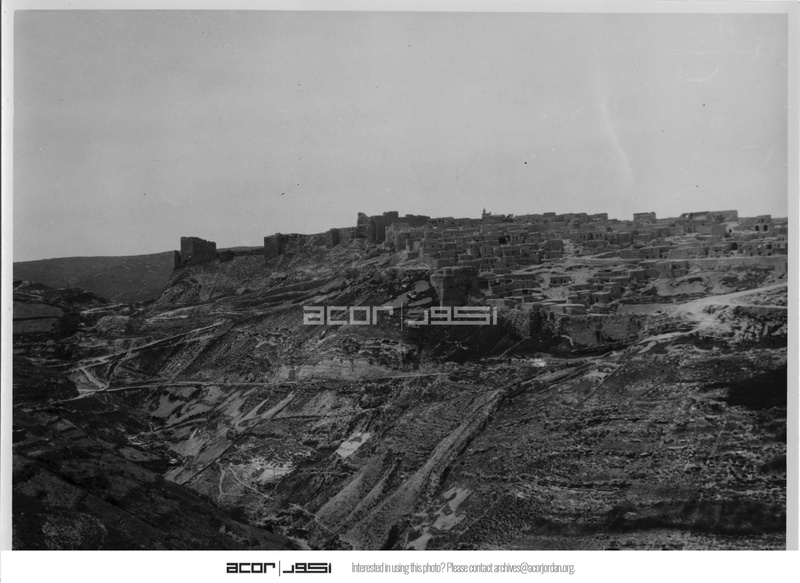
South — the road to Karak
The road south from Madaba drops through desert highlands before climbing back up to the fortress city of Karak. Wilson photographs the castle.
Kerak Castle — a name that makes historians reach for superlatives — was built beginning in 1142 CE by Pagan the Butler, Lord of Oultrejordain, one of the Crusader kingdoms carved out of the Levant after the First Crusade. It took twenty years to complete. From its walls, Raynald of Châtillon — one of the most notorious figures of the Crusader period — launched raids against Muslim trade caravans and made himself the most hated man in the region. Saladin besieged it in 1183, then again in 1184. In 1188, Saladin’s nephew Sa’d Al-Din led a final siege. The castle, cut off and starving, surrendered. It had held the Crusaders’ southern frontier for forty-six years.
Wilson stands here in 1944, six hundred and fifty years after that surrender, and takes a photograph.
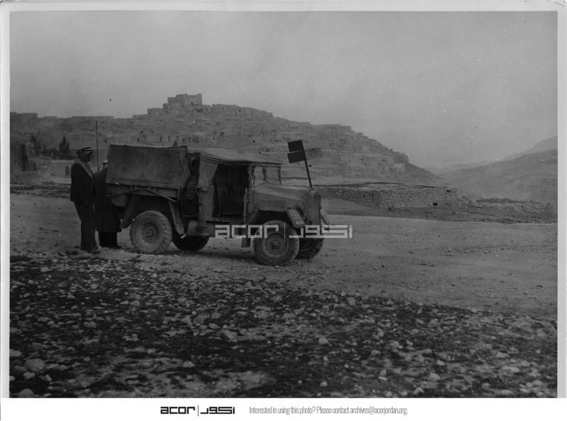
Tafilah
Further south still, Wilson photographs a 4WD pickup truck on the road at Tafilah.
It is a mundane image. A vehicle on a dirt track.
But Tafilah is not a mundane place. Exactly twenty-six years before Wilson’s photograph — on January 25, 1918 — the Battle of Tafila was fought here. T.E. Lawrence, alongside Arab commanders Jaafar Pasha Al-Askari and Prince Zeid bin Hussein, led Arab forces against an Ottoman column attempting to retake the town. Over a thousand Ottoman soldiers were killed. Arab losses were fewer than forty. Lawrence was awarded the Distinguished Service Order for it. He later wrote about it in Seven Pillars of Wisdom.
The truck in Wilson’s photo drives down the same ground. The desert has already moved on.
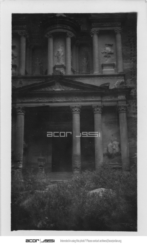
Petra
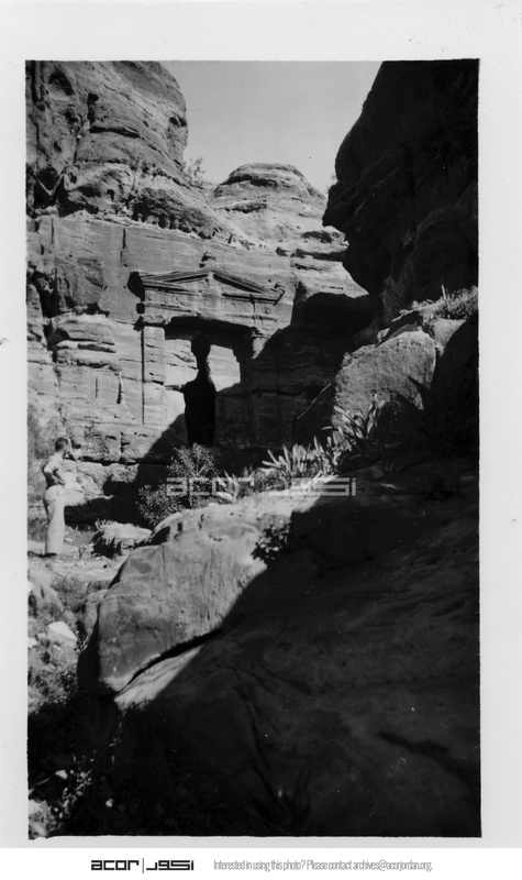
At the end of the road — literally; the route south ends here — Wilson arrives at Petra.
He photographs four structures. No tourists. No lights. No signage. Just rock and silence.
The Treasury — Al Khazneh — 24 metres wide, 37 metres tall, carved directly into rose-red sandstone by Nabataean hands roughly two thousand years ago. The name “Treasury” is a Bedouin legend: they believed an Egyptian pharaoh had hidden gold inside the stone urn at the top, and they used to shoot at it to release the treasure. The urn is solid rock. It was almost certainly a royal mausoleum or temple, not a bank. No one knows exactly when it was built. The stone doesn’t say.
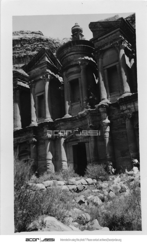
The Monastery — Ad-Deir — is even larger. Fifty metres wide. Forty-five metres high. The biggest carved facade in all of Petra, and somehow the one fewer people reach because of the 850 steps to get there. It was built by the Nabataeans, believed to be a memorial to their deified king Obodas I. The Bedouins called it “The Monastery” because of crosses carved into the interior walls — evidence of its later use by Byzantine Christians, centuries after the Nabataeans were gone. Christian hermits are thought to have sheltered here as late as the 19th century.
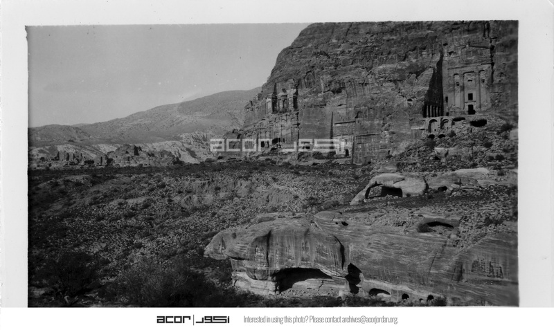
The Royal Tombs — a row of monumental facades cut into the eastern cliff face. The largest of them, the Urn Tomb, was carved around 70 CE. In 446 CE, Bishop Jason had it converted into a Byzantine church. A Greek inscription painted in red on the rear wall still records the consecration. A civilization built it as a tomb. Another civilization turned it into a cathedral. Now it is neither.
The Lion Triclinium — a funeral banquet hall, named for the two lions carved either side of its doorway, both now worn by weather into barely-recognisable shapes. Nabataean families would gather here to eat commemorative meals in honour of their dead. It is one of the most ornately decorated rooms in Petra. Wilson photographs it, and moves on.
He goes home. The war ends. Transjordan becomes the Kingdom of Jordan in 1946. The photographs go into a box.
Decades later, the collection is donated to the American Center of Oriental Research in Amman by photographer Jane Taylor. It is digitised. It is made available online.
And now you are looking at it.
This is Jordan in 1944. Before the tourists. Before the roads. Before anyone thought to call it a destination. A British officer on a wheat run, and a camera that couldn’t stop looking.
Photos: Charles Wilson Collection, ACOR Digital Archive, 1944–1945.